Bob's Intro:
After independence my younger brothers and sister attended the school (Codrington) until 1970 when the family immigrated to England. We lived whilst in Maz on the Central Research Farm with a few other families. I also have some pics of this, not enough mind you now when the nostalgia kicks in for those care free days! I have when time permitting been compiling my experiences of my 17 year childhood in NR as a memoir for my three children. It has now grown into book size and requires polishing up and pictures inserting at the appropriate places. Hence my initial search for an old map of Northern Rhodesia particular detailed area of Broken Hill where it all started.
My parents were both born in Southern Rhodesia whilst on my mothers
side both her parents were born in SA and on my fathers side his mum was
born in SA and his Dad in UK.
Have searched out a couple more pics for the collection as attached. Have one shot of the strip tar road. This was taken in Southern Rhodesia and I recall it being a stretch between Salisbury and Enkeldoren (spelling?) my great grandparents Wiggle had a farm there. My grandmothers parents. My mother could remember travelling on the ox wagons and I understood they had taken up the Cecil John Rhodes option of finding a parcel of land and farming.
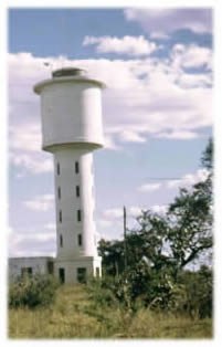
The best pic in my view is the water tower as this was the landmark seen from far away when travelling to Mazabuka. You knew you were getting closer to home.
I took some shots of every day occurrences that at the time one simply took for granted. The lad with his home made guitar, a woman pounding mealies into powder, a normal African Kia and the inevitable 'garden boy' mowing the lawn! Having had the foresight to do this I now think if only I had taken a few more. Still at the time money was not plentiful to spend excessively on photography. There is a shot of the Kafue road bridge but at home I have a couple of pictures taken from the train as it approached the rail bridge.